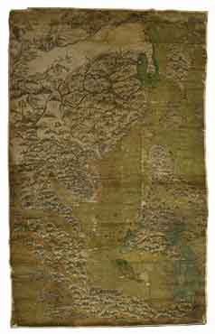
Country maps: [East Asia, including China, Korea, Japan, the Philippines, Indonesia, Southeast Asia and part of India]
Bibliographic details
- Mapmaker: unknown
- Date: c. 1620s [late Ming Dynasty]
- Scale: unknown
- Source: Bodleian Libraries / shelfmark: MS Selden supra 105
- URL: Oriental Collections Online: China, Bodleian Libraries, University of Oxford
- © Bodleian Libraries, University of Oxford, 2010
A late Ming watercolour map of East Asia, including China, Korea, Japan, the Philippines, Indonesia, Southeast Asia and part of India. The map is unusual for its outward-looking perspective, seeing China in relation to the rest of the world: the map "shows shipping routes and compass bearings from the port of Quanzhou across the entire region. A panel of text on the left of the map near Calicut, its western extremity, gives directions of the routes to Aden and the Strait of Hormuz" (David Helliwell, "The Selden Map of China", Oriental Collections Online).