Atlases
Atlas, in matters of literature, denotes a book of univerſal geography, containing maps of all the known parts of the world.
— Encyclopædia Britannica (Edinburgh, 1771: volume 1, page 502).
The earliest known atlas is Ptolemy's Geographia (Cosmographia, or Γεωγραφικὴ Ὑφήγησις), dating from c. 150 AD and surviving in manuscript copies from the Middle Ages and numerous printed copies from the Renaissance. The work is made up of five books in two parts: part one, Book 1, provides a discussion of the data and of the methods used; part two, Books 2–5, provides the atlas proper. Although representing only one-eighth of the actual globe, and increasingly unreliable the further the distance from Rome, the atlas is still a remarkable achievement, demonstrating a significant improvement in projection over earlier maps.
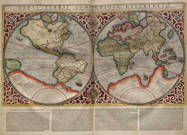
The first modern European atlas was issued by Abraham Ortelius in 1570, with the encouragement of Gerardus Mercator. Of course, Mercator was himself one of the most important cartographers of the period, particularly for the invention of the eponymous Mercator projection used to this day. Interestingly, Mercator also seems to be the first to have used the word "atlas" to describe a collection of maps.
Most commentators suggest that Mercator took the word from the mythological Greek figure depicted as carrying the heavens — or, later, the terrestrial globe — on his shoulders; and, indeed, representations of "Atlas the endurer" began to appear on the title pages of published maps from this time. However, there is some reason to think that Mercator was thinking of an elision between a later Greek mythical figure, king of north-west Africa and owner of the garden of the Hesperides, and an equally legendary primitive astronomer who Diodorus reports as creator of the first celestial globe (Bibliotheca historica, iii, 60). Mercator's own "atlas", the first part of which was published in 1578, depicts a king on the title page, which may support a conflation of "Atlas rex" and "Atlas geographicus".
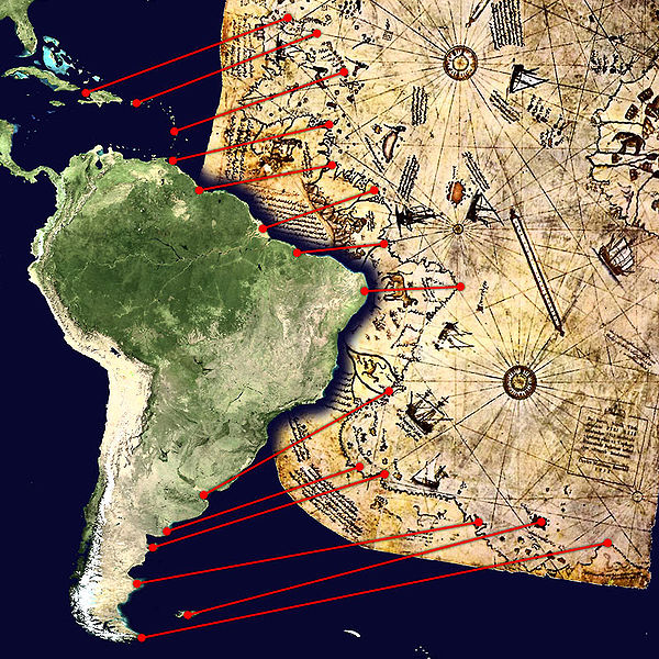
Nearly half a century earlier, another figure could be considered our first post-Classical creator of a modern atlas. Hadji Muhiddin Piri Ibn Hadji Mehmed (Piri Reis) gathered together his maps and portolani or seafaring charts into a book of navigation, the Kitab-ı Bahriye (1521); presented in this form it provided more information than any single map could accommodate. Although his information came largely from Portuguese sources, Piri Reis's accuracy is still remarkable, as a comparison of his best known map with a modern coastline of South America demonstrates.
